
During my time in Central Asia, I visited Kyrgyzstan and took a trip up to Lake Issyk-Kul and the town of Karakol, which is not far from the Chinese border, on the other side of the mountains from Xinjiang. Whilst I left Central Asia with an awareness of Xinjiang and a desire to someday go there, I left with no real understanding of the different parts of the region and this is something I'd like to explore in this blog post.
The Tarim Basin and Turfan depression
 |
| Turfan Depression by Atou Hsu |
If I've understood it correctly, the Tarim basin is slowly being pushed underground by the mountains to the north and south of it. One part of the basin, the Turfan depression is, at its lowest point, 300 metres below sea level, which is amazing when you consider that some of the surrounding mountains are thousands of metres above sea level. It's a hot and dry area, so hot, in fact, that previous generations of Turfan's inhabitants lived in underground caves, to escape the scorching temperatures of the surface.
Lop Nor
Also part of the Tarim basin are the salt marshes of Lop Nor. They occupy an area that used to be an actual lake but was eventually cut off from the sea by the shifting landmasses. It's an area of great archaeological interest and has been the source of some very well-preserved mummies that tell us a lot about the area's original inhabitants. In the 1960's, the Chinese government started testing nuclear weapons in the Lop Nor region, a controversial activity that has been (sometimes violently) opposed by the local population.
The Taklamakan
 |
| Children in Kashgar by Kvitlauk |
Most of the Tarim basin is a desert called the Taklamakan. It's the 18th biggest desert in the world and, at approximately 100,000 square miles (270,000 square kilometres), it covers a land area which is greater than the UK and slightly less than Italy. For my US readers, it's slightly smaller than Colorado. It has a reputation for being incredibly inhospitable and the name Taklamakan is believed to mean something along the lines of 'abandoned place'. Despite its inhospitable reputation, people have managed to settle in the Taklamakan, mostly in oasis towns with underground water sources, which are a result of melting ice from the northern Himalayas creating rivers that run under the Tarim basin. It's the heartland of Uyghuristan and the most important Uyghur towns, like Kashgar, Aksu and Khotan, lie on the periphery of the Taklamakan, in the foothills of the various mountain ranges that encircle the desert.
Dzungaria
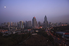 |
| Urumqi skyline by Ying Chen |
The Tian Shan mountains
 |
| Tian Shan Mountains by zz77 |
The Ili Valley
The Ili Valley of Xinjiang reminds me of the Ferghana valley in Uzbekistan, for several reasons, namely:
- it's the most fertile part of the whole region
- it's completely separate to the rest of Xinjiang
- its separate identity and closeness to Kazakhstan has earned the Ili Valley the reputation of being a hotbed of resistance to Chinese culture and rule
 |
| Lavender Harvest in Ili Valley by Arthur Ngai |
The valley has been passed back and forth, down through the years, between various different rulers, but it seems to have maintained an identity, that is neither wholly Kazakh or Chinese, Uyghur or Russian. It must have been one of the most tense border crossings between China and the (then) Soviet Union and continues to provide a refuge, escape route and different perspective from the rest of Xinjiang.
The Silk Road: trade and migration
I read an interesting theory that the history of Xinjiang is the history of trade through the Taklamakan and migration through the Dzungarian Gate. The theory goes that, because of the inhospitable nature of the Taklamakan desert, even bandits couldn't survive there, which made it a safer route to transport precious goods between China and the West. The 'southern route' became the preferred option for the Silk Road, whereas the 'northern route' via Dzungaria was too dangerous, as the steppe and colder climate could support marauding tribes. However, in terms of moving populations, the northern route was preferable, as the Taklamakan was too perilous for large numbers of humans to cross. So, goods went south, people went north.
Perhaps this explains why the south of Xinjiang (the Tarim Basin) remains to be a Uyghur stronghold, as it has been for centuries. On the other hand, more recent population movements, ie. the millions of Han Chinese who have moved to China's western province, have settled in the north, where earlier populations, such as the western Mongolians have been displaced and moved on!
Image credits:
The image of the Turfan Depression was taken by flickruser Atou Hsu - you can see more of Atou's photos at http://www.flickr.com/photos/ph0929/
The picture of the kids in Kashgar was taken by kvitlauk aka Audun K who is from Bergen in Norway. You can see more of Audun's photos on his flickrstream http://www.flickr.com/people/kvitlauk/ or contact him via his website http://kvitlauk.no/ (it's in Norwegian, but even I could understand it!)
The image of Urumqi in the evening, with the skyline, is by a journalist called Chen Ying aka chenyingphoto - you can see more of Chen Ying's photos at http://www.flickr.com/people/40713859@N00/ or on the website http://www.chen-ying.net/
The stunning image of the Tian Shan mountains was taken (on the Kyrgyz side) by flickeruser zz77 who is from Moscow. See more of zz77's photos on http://www.flickr.com/people/zz77/
The image of women harvesting lavender flowers in the Ili Valley was taken by flickruser ckngai23 aka Arthur Ngai - see more of his photos at http://www.flickr.com/photos/cknewphoto/
I've used a lot of images from flickr today - partly for the pleasure of my readers and to illustrate my blog, but also because I want to showcase some of the amazing imagery that is available through flickr. Thanks to all photographers for making these images freely available using the Creative Commons license.
1 comment:
Great to read about the Uyghurs and Xinjiang. I spent a fascinating month traveling from Kunming on a train, all the way to kashgar, via Urumqi. Hung out with friends of my uyghur student in Melbourne. They were certainly alot more fun than the new immigrants, the Han. I think things are alot more tense there now. Glad I did that trip, probably most memorable!!!!
From AL' s Melbourne friend, mel x
Post a Comment